Welcome to Brett and Emily´s travel blog.

I promise I will finish updating soon...7 more post to do!

July 13, 2010: Banos updated (pics soon)

June 23,2010: Lima and Mancura are finished (in reality Mancura was already finished but I wanted to post them in order so I need to finish Lima) with pics

June 22, 2010: I know, I know...I have been home for a month and a have a lot to update from South America. Well the Amazon was updated today with pictures!

Friday, March 26, 2010

Chilly in Chile

5 Days, 4 Nights, almost 80km...and a nice Steak (fish for Emily) meal at the end.

Interesting Fact About Torres del Paine National Park:
1) Although it is in the direct line of the Andes Mountains (the Andes are both North and South of the mountain range in the park), it is evidently an independent mountain range with no connection to the Andes.
2) ´Paine´ is a native word that means ´blue´ which evidently has to do with the blue color the glaciers use to give off thousands of years ago

 Some sort of cool llama looking animal that is every where in the park

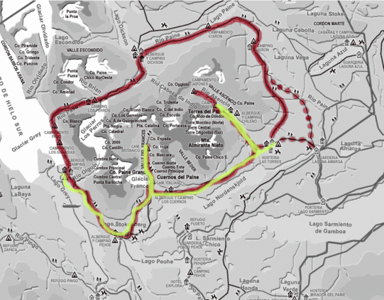
After spending a day and a half in Puerto Natales, Chile mainly resting the many wounds on my feet caused by the ´great´ sidewalks of Argentina, attending a hour and half seminar on trekking in Torres del Paine National Park, and shopping at a supermarket that is basically a trekkers paradise (small bags of everything: spices, jams, condiments, etc.) we finally headed off to the National Park on Wednesday (17/3).  The park was a 3 hour (+coffee break) drive from the town and after paying the park entrance we continued on the bus to a launching point for a boat to take us to the bottom left corner of the ´W´ (see the map below).   While we were waiting for the boat we were told to take a nice 20 minute walk to a overlook of a small waterfall.  It was a nice small waterfall but after being at the Iguazu Falls all waterfalls kind of seem lame to me.  After we finally boarded the boat and disembarked 40 minutes later, Emily and I began our trek to the first campsite.  In reality it was a pretty short hike and mostly downhill (only 3.5 hours) but because it was the first day it took us 4.5 hours.  Along the entire hike though we saw amazing views of Grey Glacier, until we hit the campsite and realized just how close we were to the glacier. 

 Glacier Grey in the background (this was the view of the majority of our first day of hiking)

Cool Geology, looks like a fingerprint

The campsite was along the beach of the glacial lake and large and small chunks of ice were floating about infront of the campsite.  The relative closeness we were to the glacier that night probably had something to do with the next morning when I went an extended rant about how cold it was and who ever had the ´great idea´ of sleeping next to a glacier was crazy.  The campsites are kind of weird at the park.  There are both free and pay sites (that are run by different companies, that I assume are contracted out by the Park Service).  The freesites seem to be a bit out of the way most of the time, while the pay sites are more conveniant and less of a hassel normally to get to.  Also attached to all the paysites are ´refugios´ or small hostels that more rich/older people stay at that provide both cooked meals and a place to sleep (and quiet a price) so you don´t need to backpack with basically anything except clothes.  The nice thing about these sites though is they also have minimarkets which allowed us to buy a carton of wine (if anyone from my garin is reading this it was Gato Negro) to enjoy with our dinner that dinner. 

On Thursday we left the campsite and hiked a small 20 minute path to a great lookout of the glacier.  We then retraced the path back down to the bottom left corner of the ´W´ where we got dropped off the boat on the first day.  Even though there was more uphill during the retracing we managed to go a bit quicker (a little under 4 hours).  We had lunch and headed towards the next campsite (about 2.5 hours away) directly in the middle of the bottom part of the ´W.´  Although we couldn´t see it, we could hear a hanging glacier not to far from the campsite.  Now I wasn´t exactly sure what a hanging glacier was until we saw it the next morning.  I knew what a regular glacier was, like the one we saw the previous day or the ones we saw in Los Glaciares National Park that are part of a larger ice field and basically carve out valleys and is created/maintained by snow (during the winter) from mountains melting (during the spring) and compacting into the icefield.  As I found out the next morning a hanging glacier is more like a large amount of icy snow that is compacted on the side of a mountain.  When a piece of icy-snow falls it is not like the regular glaciers where just large chunks of ice fall off in to a lake, but it causes more of a small avalanche of snow that flows down the side of the mountain.  All night we could hear this going on and it sounded like a thunderstorm in the distance that just never got closer or father. 

 Closer up view of Glacier Grey that we saw the second day

Entrance to the second campsite

The third day, even though it was the longest hiking (8 hours), 6 hours were done without our packs on.  We hiked up and down French Valley (the middle stem of the ´W´), which was 3 hours each way.  From the top we just had amazing views of the entire valley: the plains at the bottom of the valley, the granit mountain tops, hanging glacier, etc.  After we returned to the original camp we packed up camp around 15:30 and made our way to a pay site just two hours walk away. 

 View from the top of French Valley

The next morning we woke up, surprisingly not freezing cold as we had the two previous nights (which might have had something to do with the weather being a tad warmer, but I am convinced it had to do with the fact we weren´t sleeping right next to a glacier for the first time in three nights).  The weather was bit worse then what we had been having.  Which luckily had been pretty sunny (we heard from everyone to expect 4 days of downpour, one Israeli even told some people we met that Torres del Paine was more like ´Torres del Trauma´).  The first half of the day was pretty drizzly and as we crossed a huge plain we hit pretty cold winds.  As we began to make our way up the far right of the ´W´ we started to experience more and more wind, which only made the semi-drastic uphill we were doing that much harder.  At one point going up in to the valley we turned a corner on the side of a mountain and almost got thrown right off the mountain the wind was so strong.  We finally hit the paid campsite and even though it was marked we only had another 90 minutes to the freesite we decided we were making good time so we decided to stop inside the refugio and drink some hot mate and play backgammon bit.  We finally laced back up our boots and made it to the freesite, the nice thing being even though we continued to go uphill we were now in much more of a tree cover so we just heard the heavy wind run through the leaves.  The only upside to the day was that we took a nice short-cut, the trail we took was marked for 7.5 hours without stops, but a nice shortcut that took us through a valley instead of having to go completely downhill to then go back uphill, saved us a nice 1.5 hour. 

 View of the final leg of the trip

The final morning was the morning we had been waiting for the entire trip.  We were told in a short seminar we took before the hike at, ErraticRock, that we need to wake up mad early the final morning and hike before sunrise to a glacier which was about a 45 minute hike but almost at 45 degrees uphill and a very rocky/sandy semi-marked trail.  Needless to say the trail was not so fun to do in the pitchdark but when we got up there about 5 minutes before sunrise we quickly setup our sleeping pads and started to cook our breakfast.  As the sun began to rise and hit the glacier, and the peaks above the glacier, the entire area glowed an amazing orangish-red color.  Hopefully the pictures can do some justice but it was undescribeable.  We then ran back to the campsite packed up and for the first time before 10:00am all week we were on the trail, and basically sprinted down from 886m to around 50m above sea level (we ran not because we were in a total rush for time, we made it to the bus stop 2 hours early) but because it hurt my knees a lot less then walking it).

The following is three pictures during sunrise of the Three Towers


We finally got back in to town and after returning some gear (walking poles for my old-legs and rain pants that I rented as insurance after our hike in El Chatén) and moving hostels we went out to dinner with some friends we met along the trail and I enjoyed a nice steak with a sunny-side-up egg and some fries.

Quick-side not we would like to share our camping-culinary expertise with the world...
-First Night: As it was the first day we decided to hike in with some extra veggies and Emily made a pleasent Veggie Rice Curry (I also brought along some chicken sausages).
-Second Night: Typical Pasta and Tomato Sauce
-Third Night: Our true culinary masterpiece.  Mini-Pizzas.  Yes that is right we brought along these flat circular bread-rolls that we sliced in half, then added tomato sauce, onion, oregeno, garlic salt, and cheese.  I then placed 4 small rocks on the bottom (balancing the pizza on the rocks) of my cooking pot put a little water on the bottom and closed the pot.  90 seconds later...MINI PIZZAS with melted cheese and all.
-Fourth Night: Pasta with alfredo sauce (from a packet), which we neglected to notice needed milk.  So we added a bit of cheese and some leftover tomato soup and it tasted pretty good.

After a quick layover back in El Calafate we are now in Bariloche (after a beautiful 29 hour bus ride, which went through our ´most favorite´ town in Argentina, Rio Gallegos.

Tuesday, March 16, 2010

Walking on a ´W´

As we won´t be able to update for the next few days, because we will be on a five day hiking trek in Chile, I decided to give you all a preview of what we will be up to.  Currently we are in a small little town, in Southern Chile, about 15 minutes from the Argentinian Border known as Puerto Natales in the Magallanes Region.  The town is a jumping off point to Chile´s Torres del Paine National Park, where we will be trekking the famous ´W´ trek.  The park is considered a United Nations Biosphere Reserve, what ever exactly that means.  On the map below we will be hiking the yellow ´w´ part (the rest of the trail is known as the circuit and takes between 7-10 days).

Feel free to read more about the trek...CLICK HERE


Besides that HAPPY SAINT PADDY´S DAY to all.  We will try to find an Irish Pub in town tonight (because please it isn´t a real town if it doesn´t have an Irish Pub) to have a few pints.

-Brett

Sunday, March 14, 2010

¨ICEBERG DEAD AHEAD¨

We arrived in El Calafate, returning to the Province of Santa Cruz (which is the same province that Rio Gallegos is in but the other side of the province).  After getting in to town, around noon, we decided to spend the day at the hostel talking to people about different things to do in the area and different treks.  Also because almost everything to do you must catch a bus pretty early in the morning it was impossible to do much that day anyway except to walk around the one major downtown street in town and walk through the way over-priced camping stores (which we happened to run in to some Irish friends from our travels in Paraty, Brazil, and later in the night met up with them for some beers).  One nice thing though was because the hostel knows everything to do here you must leave early in the morning, they start breakfast at 6:30am (normally most hostels don´t start until 8am at the earliest, most the time around 9am).

Map of the Region

In reality there is very little to do in the town of El Calafate but it has grown and adapted tourism because it is the main hub to go to 4 major places.  Two of which we have done (and will talk about below) and the other two we are planning on doing.  The first thing we did from El Calafate was a day visit to Los Glaciers National Park.  This part of the park is about an 80 minute bus ride from town, and you must also pay admission in to the park.  The main attraction here is the Perito Moreno Glacier, which the Argentinians have built an extensive/elaborate amount of walkways (which we have seen Argentinians are very good at doing at Iguazu Falls and now here) to view.  This glacier is one of a series of glaciers (I don´t know how many are officially in the park but there are 48 glaciers in the Southern Patagonia Ice Field) which make up the national park and are all kind of connected along Lake Argentino.  Surprisingly you can get very close to the glacier, and see both little pieces fall off the glacier probably every two or three minutes and also during the high-noon period of the day we witnessed 3-4 large chunks come collapsing off the glacier causing small tidel waves in the lake.  These larger collapses would leave hundreds of small chunks of ice and also always a very sizeable iceberg in the lake, which you could see a few dozen from previous days throughout the lake.  You might think because of all this activity the glacier is shrinking yearly in size, but according to the Park Rangers it is a pretty stable glacier because in the winter it almost completely expands back to its original place.

Great Overview of the Glacier

View of the Glacier through the eyes of Emily

Emily stop trying to lick the Glacier...that is dirty ice

That is a tall glacier

The next day we took an afternoon bus to about 3 hours away to a town called El Chaltén to begin 2.5 days (which ended up being 2 really quick days) of trekking in another part of Los Glaciers National Park (this part of the park, because it is less touristy then the falling glacier, is free admission and camping).  The bus in to town took a little longer then we were told because of a few stops along the way (one at a hotel with a cafe which is semi-famous because Butch Kassidy and The Sundance Kid hidout there for several months after they robbed the banks in Rio Gallegos) so by the time we arrived in town and had to take care of a few other small things it was to late to hike up to the first campsite within the National Park (a 3 hour hike).  The original plan was to hike 3 days for about 3 hours a piece a day.  So instead we decided to find a cheap campsite in town and setu camp there for the night and headout the next morning and just do about 5 hours of hiking one day and 4 hours the next day.  So the next morning we woke up and after a good breakfast of  hot oatmeal we packed camp and headed out towards the closest overview of Cerro Torre (which was right next to the campsite we were suppose to stay at the night before).  When we reached the overview area which was from the otherside of a lake from a glacier and then the Cerro Torre Mountain in the background it all of the sudden got extremely windy (strong enough to even make me lose my balance) with a light rain.  We kind of assumed this was just because we were near the base of the mountain and glacier but as we began to back track to hit another trail to get to another campsite the rain kept getting worse and worse.  We began to book it across this trail in horrible pouring rain and extremely strong winds which more then one time threw us off the trail.  Because it was so wet we tried to do the trail as quick as possible completing what was marked as a 3:15-3:30 trail in 2:05.  Pretty impressive but lets just say we were pretty wet (clothes and boots) and exhausted by the time we hit the campground that we setup our tent as quickly as possible trying to keep the inside as dry as possible (which we weren´t that succesful at doing) and didn´t even try to make dinner just passed out for 12 hours (and yes the really bad rain/wind storm continued the better part of the night.  Even though at one point I woke up to go to the bathroom and the storm stopped but it was lightly SNOWING!!).

(Note: to check out trail maps of what we hiked go to the bottom of this post)

Top viewing point for Cerro Torre (to foggy to see the mountain) but you can see the glacier in the background.  When the picture was take the wind was way over 40mph.

Evidently English and Spanish speakers need one line to tell them to pick up their garbage...ISRAELIS NEED TWO!

The next morning when we woke up we were lucky to find that we setup in a pretty good dry-zone in the campground.  Only our clothes from the previous night and boots really got wet and needed to dry.  Luckily for our boots emily had her book with her and was already done reading well over 500 pages so we began ripping out what she had read from the book and stuffing our boots which after two rounds of stuffing finally dried out our boots.  So around 1pm we decided to hike the little over one hour trail up to FitzRoy Mountain.  The trek was a great complete uphill which we saw icicles, had some snow fall, and when we got  to the top an amazing view of the FitzRoy Mountain covered by snow.  At this point it was around 2:15pm and we had to book it into town to make a 6pm bus back to El Calafate.  They say you need about 3:30 hours from the mountain top to get back in to town the only problem was we had to go back to camp breakdown our campsite and make it in to town.  We hit the town just after 6pm and made it to the bus station just to see our bus pull off (with my pack on I tried to chase the bus down but the driver didn´t notice me).  Luckily another company had one more bus for the day at 6:30pm, so we paid (even though we already had paid for the bus we missed) and made it back in to El Calafate around 9:30pm.

Emily ripping up her book, good thing she had finished so much of it already.

A view of FitzRoy from the top of the hike

View of C. FitzRoy and C. Torre from the valley

Today we have decided to take it pretty easy catching up on somethings and getting ready to leave for Puerto Natales, Chile tomorrow which we plan on doing a great 5 day trek in Torres del Paine National Park.  (Note: Like I said in a previous post, this portion of Chile is several hundred miles away from where the earthquake occured and as we have heard from other travelers there is no problems in this region).

 First Day Hiking is in highlighted in the Red.  We left from El Chatén.  When we hit the Lake at the end of the trail is when it started raining.  We then hussled back down the trail to that cross trail that heads directly north (not highlighted) and finished the First Day at the campsite at the end of that trail.

(Hiked between 11:00-19:00, included long breaks to enjoy the views)


Second Day of hiking we started at at Camp Poincenot and headed West toward Lag. de los Torres (extremely uphill, but worth the pain).  We then hussled back down to the campsite packed our gear and hussled back down to El Chatén, barely missing our bus. 

(Hiked between 13:00-18:10, pretty quick pace with out many water breaks and about 20 minutes to break down camp)

The Engagement... the moment you have all been waiting to hear about

On Saturday night (about a week ago already), Brett and I were camping out at a very beautiful spot in the National Park in the very southern tip of Argentina. After cleaning up from dinner, we were watching the stars come out. When I turned to give him a kiss, he said "I have a question, will you marry me?". I was so shocked (yes, I figured this was coming sooner or later, but I didn´t expect it until after this trip) that I said "really?". He said "yeah, really", so I said "yes". We stood there talking and watching the stars for a bit more after that, and I asked him "really? Are you sure? So we are actually engaged now?" about 2 dozen times. Just to be sure.

The view of our campsite from across the river (the yellow thing is our tent)

Another view from across the river (again the yellow dot is our tent)

Since we were camping, there was about a 24 hr period where no one but us knew that we were engaged and we had no way of calling anyone back home to share the news. It was a kind of bizzare secret. Once we got back to the hostel though, we spent lots of time on skype calling friends and family (we apologize if you did not recieve a phone call, but it was pretty tough getting in touch with everyone from here).

The view from our campsite

Sunset at the campsite (about a half an hour before the proposal)

We are not doing any wedding planning until after this trip, so no date is being set yet. However, the wedding will be in the Detroit area.

Also, rumor has it that there is a ring waiting for me at Brett´s parent´s house in NJ.
-Em

Thursday, March 11, 2010

Where the road won´t go any more south...Ushuaia

So from Buenos Aires we flew to Rio Gallegos (the ´ll´is pronounced as a ´j´) which is a boring town and has absolutly nothing to do.  The only thing I think the town is famous for is there was a major robbery here by Butch Kassidy and the Sundance Kid, it is the capital of the Santa Cruz Province of Argentina, and the past and current Presidents of Argentina are from here (The Kirchner´s).  The reason we decided to fly in to Rio Gallegos was because it was $50US cheaper to fly there then all the way down to Ushuaia.  We then learned the next morning when we went to the bus station to head as fast as possible out of the town that the bus to Ushuaia was for to be $P200 (Argentinian Pesos) which is almost equivalant to $50US.  The bus ride down to Ushuaia was a 12 hour bus ride which left at 8am, we were hoping to take an overnight bus but learned very quickly why there are no overnight buses between Rio Gallegos and Ushuaia.  There is no technical way by land/staying in Argentina the whole time to get to Ushuaia (take a look at the Argentina map on the right side of the blog Ushuaia is the way South).  So to get to the Tierra del Fuego Province of Argentina you must cross in to Chile, drive through Chile for 4 hours the cross back in to Argentina.  Which means having to get on and off the bus 4 times for passport control.  Also during this time we had to cross the Straight of Magellen which meant waiting for a ferry across the Straights. When we finally arrived in Ushuaia around 8pm Emily and I were about to kill ourselves and each other.  So basically in the end the fact that we saved absolutley no money and had to sit on a bus ride from hell, we learned our lesson and strongly recommend just flying straight to Ushuaia from Buenos Aires. (Side Note:  Yes we were in Chile but probably well over 1,000km from where the earthquake happened.  So where we were seemed absolutley normal and like everything was running fine, but that is not much to say as it was so far away from the epicenter, it is like asking if there was an earthquake in Minneapolis, is everything ok down in Tulsa?)

Straight of Magellen in Chile

Emily loves to stick her feet in water, the water in the Straight of Magellen was a ´tid bit nipply´

We spent 4 days down in Ushuaia which was absolutley amazing.  The furthest south city in the world, is a gorgious town of 66,000 people completely surronded by mountains and a bay.  A quick outline of what we did will follow but for the most part the pictures can do most of the talking.  The first day we were in town we decided to go to the museum of the history of the Patagonia (which is the general name given to the Southern region of Argentina and Chile), , called the Musuem of the End of the World, which talked about the earliest explorers in the region, the native populations who lived in the region (who are almost all extinct now) and the founding of the town of Ushuaia.  We also later in the day took a ski lift to a great overlook of the town.  Unfortunatley we arrived a little late and didn´t have time to see the glacier which was about another hour hike, before the park closed.  I was pretty disappointed because I wanted to see a glacier (Emily has seen one before in Alaska), even though we read this one was nothing comparable to one that we were planning on seeing in El Calafate.

View of Ushuaia from our hostel room window

SNOW!!  No time to see the glacier though :(

On the way back down the chairlift

The second and and third days we decided to head into Tierra del Fuego National Park. It is a very beautiful national park with a road in it that is the most southern road and it ends with a sign announcing that this is as far south as you can go. There is a nice free camping area, and since this is the end of the busy tourist season (summer has just ended and the kids are back in school in Argentina), there were other campers, but it was not too crowded. We camped by a nice stream with mountains overlooking the site and did some nice day hikes, although not as much hiking as planned, since it rained a bit and we decided to wait out the rain in the dry tent. That night, while camping out we got engaged, but we can save details on that for another blog posting.  We did a relativly short hike the first day to a sign/dock which demarks the end of Argentina Highway 3 and is also the furthest southern road in the world (so they claim).  The second day we went on a longer 3 hour hike along the Southern Coast ending at another dock and look out point which also has a post office which you can get your passport stamped (saying you are ¨At the End of the World´ or send a postcard stamped from the ´Farthest Southern Post Office in the World´).  Unfortunatley it was Sunday so the post office was closed so no stamps, so sad (even though Emily didn´t want to get a stamp because she is fearing she will run out of room in her passport, causing a problem if we try to cross an international border and she has no room for an entrance stamp).


(Note: A Park Map is on the bottom of the post)

Sipping maté at the campsite

Legit the road doesn´t go anymore South then this point (also evidently Alaska is 17,000+ km away)...

At the end of the World (even though there are still a bunch of Islands more South)

Beautiful Panoramic View of the ´End of the World´

The Farthest Southern Post Office in the World (so Argentina claims) at the end of the second day of hiking (also at this point we had been engaged for almost 16 hours and no one knew)

We headed back in to town and the next day decided to sign up for a Boat Tour through the Beagle Channel to see penguins.  The tour took about 6 hours round trip the first 3 hours there were 4 major stops.  The first was to ¨Bird Island¨which has a large group of birds which look a lot like penguins but evidently aren´t penguins.  The second stop was ¨Sea Lion Island¨ where we got to see more of the same ¨fake-penguins¨ and more importantly Sea Lions.  The third stop was to a famous Light-House which even though its name is ¨The End of the World Light-House¨ they told us on the boat ride that there is technically one further south in Chilean Territory.  The last stop was the one everyone had been waiting for was...THE PENGUINS!!!  Emily commented, ¨that it was good we didn´t take the bus ride (which was a bit more expensive and you only got to see the penguins, but you get to walk around the island where the penguins are) because [she] probably would have tried hugging them, with bad consequences.¨ Eitherway, we got incredibly close and saw the penguins wobbling, swimming, just plain standing around, trying to walk up hills, and playing around in the water.  It was a pretty cool experience.  The island that we saw the penguins has two types of penguins on them, one that stays there all year and one that evidently travels around but is always on that island during a period of the year.  The boat ride back was less entertaining but it was a pretty nice boat and they wisely showed ¨The March of the Penguins,¨ although in Spanish.

Note from Emily: Our first one hundred guests to the wedding have already RSVP´d.  They are all ready and dresed for the wedding in their cute little tuxedos.  Their only request is that there be fresh fish on the menu.

A Sea Lion (in the middle) and birds that are not penguins

It was raining at the beginning of the boat ride when it finally cleared up we got this beautiful rainbow

PENGUINOS!

PENGUINOS UP CLOSE!

PENGUINOS SWIMMING (I have a great video of one jumping out of the water)

The next morning we woke up and headed towards the airport on the way to fly to El Calafate.  We decided to fly even though it was twice the price just because we were going to have to take the same miserable 12 hour bus ride to Rio Gallegos then transfer to El Calafate (another four hours) and we didn´t feel like taking the horrible bus ride and dealing with all the border crossings again.

¿¿¿´Flintstones, meet the Flintstones´ no idea why they had the Flintstone´s car in the middle of town but they did???

The First Day we hiked from that Large Island (where our campsite was) Southward towards the dock at the corner of the mapWe then after taking some pics (check them out above) turned around and planned on hiking up the trail along the West (left) side of the map by Lago Roca, but when we hit the crossroads it started to rain and we headed back.  The second day we headed from the Island and did the trail along the Southern (bottom) edge of the map (which took about 3 hours) and then decided to hitchhike back to the campsite.

Wednesday, March 3, 2010

Colonia del Sacramento, Uruguay; Mar del Plate, Argentina; and back to Buenos Aires

Last Thursday we decided to take a nice day trip over to Colonia del Sacramento, Uruguay (better known as just Colonia).  To get over there you need to take a boat from Buenos Aires along Rio de la Plata, which is evidently the widest river in the world although I think it is really more of just a wide harbor.  Emily and I decided to be Jews, aka cheap, and take the slow boat which takes 3 hours instead of just one hour for about half the price.  We in the end kind of got lucky and our boat got canceled so they put us on the fast boat but it left two hours after our boat was suppose to so we go in to Uruguay at the same time.  One really nice thing that they did though is before you leave Buenos Aires you go through passport control for both Argentina and Uruguay.  You basically hand the first guy your passport he finds your Argentinian entrance stamp and gives you the corresponding exit stamp and then he hands it off to the next guy who gives you your Uruguayan stamp.  We arrived in Uruguay around noon and had about 7 hours to just walk around the old Portuguese/Spanish Colonial town eating lunch, walking around and checking out the nice views along the river and and checking out the historical buildings of the town, and also learning about the history of the town and a little bit about Uruguay.   To give just a brief history of the town was it was founded by the Portuguese but traded time something like 7 times in about 100 years.  It ended up eventually in Spanish hands because the Spaniards were not happy that the Portuguese were smuggling goods in to Buenos Aires (which at the time was only allowed to trade with Spain).  When Argentina began its revolt from Spain in 1810, the region of Uruguay also as it was considered just another part of the same Colony.  Eventually however when Argentina gained its independence the region of Uruguay didn´t send any delegates to the new national assembly and declared their own country.  To this day evidently much is similar between the two countries including they both lay claim to the origin of Tango dance and music, being the first to drink maté, and even their flags are pretty similar (Argentinian Flag and Uruguayan Flag).  However, overall the town was really nice and was a great day trip from Buenos Aires (many people also continue to either Montevideo or to the Uruguayan coast, a city named Punta del Este which is South America´s Monte Carlo.)

A picture of some of the Porteguese Colonial Buildings, Old City wall, and Rio de la Plata in the background in Colonia del Sacramento

Picture of Emily and I on top of the old city walls 

When we got back to Argentina later in the evening (we didn´t get so lucky with our boat back and had to sit on a three boat, but they are huge cruiseliners with cafes, dutyfree, and entertainment so it wasn´t to bad) we then went back to our hostel and got ready to head to Mar del Plata, Argentina and visit Emily´s friend Isaac.  The town is a 5 hour bus ride from Buenos Aires, and is along the coast.  Even though Mar del Plate is a tourist city, it is for the most part only Argentinian tourists who come to the town for the beaches.  We were there during the last week of summer which I would assume is much like Labor Day in the states but our friend Isaac told us that it was actually a less busy weekend then most weekends during the summer.  We enjoyed a great weekend of not having to pay for a hostel and just a nice leisurely weekend.  We for the most part just walked around the main areas of the city because we didn´t feel like spending to much time on the super crowded beaches.  Isaac also took me to a great Argentinian steakhouse which for the glorious price of basically nothing we enjoyed a huge slab of beef ribs, a huge 14 inch cut of beef (which he said you can only find the type of cut we had in Argentina, entralada), and a chorizo sausage for under $20US.  Overall, the town was really nice and was much like any beach town you would go to in the states.

Funny, random looking seal (there was another one on the otherside of the staircase) in Mar del Plata that everyone wanted to take their picture with

Great picture of 3 dogs in the shade (with the ocean/beach in the background)

We returned from Mar del Plata to Buenos Aires on Sunday (both my birthday and purim).  We decided to celebrate more my birthday where I enjoyed at a 4 star restaurant: a platter of three different types of steak, bottle of wine, 2 glasses of water, and a grilled salmon on a salad bed (Emily´s dinner) for $25US.  As my dad said in NYC or London that would probably cost between $100 and $150.  On Monday we went to the legendary La Boca.  Which has a nice touristy street with brightfully colored buildings.  The neighborhood is known as the working class neighborhood of Buenos Aires (and also infamous for its soccer team the Boca Juniors who were out of town during my whole time in BA).  I was kind of unimpressed by the area, the building were nice and all but it was over the top touristy with annoying hostesses from restaurants constantly bugging you to eat at their place.  Like in other parts of Buenos Aires there were tango dancers outside giving street performances and also nice art vendors but as it is only safe to walk on a few block area of the neighborhood I just didn´t like it to much.  Last night we also decided to go to a main attraction in Buenos Aires, called La Bamba.  It is basically this huge outdoor concert, for 3 hours twice a week, put on by a famous drum/trumpet band between two factories with 1,000 people partying along.  It was pretty out of control and a great time, even though Emily and I only saw the last part of it because of the long entrance line. Finally today was a bit more calm and we took a nice pleasant walk along the old river/harbor area of Buenos Aires which like many other cities has now been converted into nice apartments and a nice boardwalk area.  Additionally we did a pretty nice walking tour (which I´ll explain more in the photos I upload) which was in the Lonely Planet whose highlights included Evita Peron´s grave and a large flower statue which open and closes with the sun.

An old Argentinian Naval Ship (and its big guns)

Eva Peron´s (aka Evita) Moselium 

A view of one ´block´of moseliums (there were hundreds of them) in Buenos Aires´elitist cemetry

Metal Flower Sculpture that closes and opens with the sun

Tomorrow we are flying down to Patagonia Region of Argentina which will be the beginning of a lot of trekking and seeing penguins, glaciers, whales, and much much more.