
Straight of Magellen in Chile

Emily loves to stick her feet in water, the water in the Straight of Magellen was a ´tid bit nipply´
We spent 4 days down in Ushuaia which was absolutley amazing. The furthest south city in the world, is a gorgious town of 66,000 people completely surronded by mountains and a bay. A quick outline of what we did will follow but for the most part the pictures can do most of the talking. The first day we were in town we decided to go to the museum of the history of the Patagonia (which is the general name given to the Southern region of Argentina and Chile), , called the Musuem of the End of the World, which talked about the earliest explorers in the region, the native populations who lived in the region (who are almost all extinct now) and the founding of the town of Ushuaia. We also later in the day took a ski lift to a great overlook of the town. Unfortunatley we arrived a little late and didn´t have time to see the glacier which was about another hour hike, before the park closed. I was pretty disappointed because I wanted to see a glacier (Emily has seen one before in Alaska), even though we read this one was nothing comparable to one that we were planning on seeing in El Calafate.

View of Ushuaia from our hostel room window

SNOW!! No time to see the glacier though :(

On the way back down the chairlift
The second and and third days we decided to head into Tierra del Fuego National Park. It is a very beautiful national park with a road in it that is the most southern road and it ends with a sign announcing that this is as far south as you can go. There is a nice free camping area, and since this is the end of the busy tourist season (summer has just ended and the kids are back in school in Argentina), there were other campers, but it was not too crowded. We camped by a nice stream with mountains overlooking the site and did some nice day hikes, although not as much hiking as planned, since it rained a bit and we decided to wait out the rain in the dry tent. That night, while camping out we got engaged, but we can save details on that for another blog posting. We did a relativly short hike the first day to a sign/dock which demarks the end of Argentina Highway 3 and is also the furthest southern road in the world (so they claim). The second day we went on a longer 3 hour hike along the Southern Coast ending at another dock and look out point which also has a post office which you can get your passport stamped (saying you are ¨At the End of the World´ or send a postcard stamped from the ´Farthest Southern Post Office in the World´). Unfortunatley it was Sunday so the post office was closed so no stamps, so sad (even though Emily didn´t want to get a stamp because she is fearing she will run out of room in her passport, causing a problem if we try to cross an international border and she has no room for an entrance stamp).
(Note: A Park Map is on the bottom of the post)

Sipping maté at the campsite

Legit the road doesn´t go anymore South then this point (also evidently Alaska is 17,000+ km away)...

At the end of the World (even though there are still a bunch of Islands more South)

Beautiful Panoramic View of the ´End of the World´

The Farthest Southern Post Office in the World (so Argentina claims) at the end of the second day of hiking (also at this point we had been engaged for almost 16 hours and no one knew)
We headed back in to town and the next day decided to sign up for a Boat Tour through the Beagle Channel to see penguins. The tour took about 6 hours round trip the first 3 hours there were 4 major stops. The first was to ¨Bird Island¨which has a large group of birds which look a lot like penguins but evidently aren´t penguins. The second stop was ¨Sea Lion Island¨ where we got to see more of the same ¨fake-penguins¨ and more importantly Sea Lions. The third stop was to a famous Light-House which even though its name is ¨The End of the World Light-House¨ they told us on the boat ride that there is technically one further south in Chilean Territory. The last stop was the one everyone had been waiting for was...THE PENGUINS!!! Emily commented, ¨that it was good we didn´t take the bus ride (which was a bit more expensive and you only got to see the penguins, but you get to walk around the island where the penguins are) because [she] probably would have tried hugging them, with bad consequences.¨ Eitherway, we got incredibly close and saw the penguins wobbling, swimming, just plain standing around, trying to walk up hills, and playing around in the water. It was a pretty cool experience. The island that we saw the penguins has two types of penguins on them, one that stays there all year and one that evidently travels around but is always on that island during a period of the year. The boat ride back was less entertaining but it was a pretty nice boat and they wisely showed ¨The March of the Penguins,¨ although in Spanish.
Note from Emily: Our first one hundred guests to the wedding have already RSVP´d. They are all ready and dresed for the wedding in their cute little tuxedos. Their only request is that there be fresh fish on the menu.

A Sea Lion (in the middle) and birds that are not penguins

It was raining at the beginning of the boat ride when it finally cleared up we got this beautiful rainbow

PENGUINOS!

PENGUINOS UP CLOSE!

PENGUINOS SWIMMING (I have a great video of one jumping out of the water)
The next morning we woke up and headed towards the airport on the way to fly to El Calafate. We decided to fly even though it was twice the price just because we were going to have to take the same miserable 12 hour bus ride to Rio Gallegos then transfer to El Calafate (another four hours) and we didn´t feel like taking the horrible bus ride and dealing with all the border crossings again.

¿¿¿´Flintstones, meet the Flintstones´ no idea why they had the Flintstone´s car in the middle of town but they did???
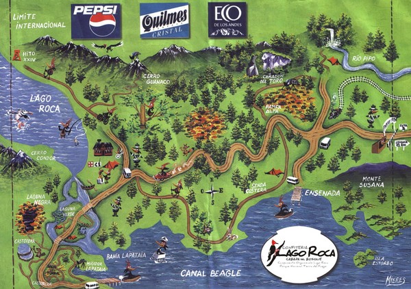
The First Day we hiked from that Large Island (where our campsite was) Southward towards the dock at the corner of the map. We then after taking some pics (check them out above) turned around and planned on hiking up the trail along the West (left) side of the map by Lago Roca, but when we hit the crossroads it started to rain and we headed back. The second day we headed from the Island and did the trail along the Southern (bottom) edge of the map (which took about 3 hours) and then decided to hitchhike back to the campsite.


you guys have taken some amazing photos! i like the penguins!
ReplyDelete